|
Death Valley
Circumstances associated with my room caused an
earlier arising than I’d hoped for and an hour delay in my leaving. I’d
thought to leave fairly expeditiously, just grabbing something quickly
at a McDonalds on Sahara on the way to the highway, and try to get a
gallon of emergency water, since I was headed for Death Valley today. I
was a bit nervous since it had snowed in the Sierra Nevada the day
before, and I wasn’t sure if any of the four mountain ranges I was to
cross today would be affected. If I’ve driven in ice or snow it’s been
decades, and I have rented a sub-compact with no chains. Eventually I
got the phone numbers for road conditions in Nevada and California. The
latter wouldn’t work in Nevada, and finding that Nevada seemed clear, I
decided to go for it. I’m glad I did. I did get a pic of the Moodies
pic and the huge outdoor Hilton sign. It is a big sign at the top of a
stylized thing several stories high.
| There were two routes to get there. Mapquest suggested the
northern one; I took the southern one past Red Rock Canyon and
through the Indian village of Shoshone up to Death Valley
Junction. Once in the park I hit all the best bits, starting with
Dante’s View. I’m not sure why so many things are called Devil’s
this and Dante’s that, but the view was Sweet! It was quite a
climb to the top and then you see the entire immense valley with
the high mountain range on the other side and the salt flat down
at the bottom. At Dante’s I’ve read somewhere you’re up 5,000
feet above the valley, which is 282 feet below sea level at its
lowest point. The town of Furnace Creek is over 100 feet below
sea level. It was all great for photography. The rain and
clouds that had been threatened for Sunday did not materialize,
and in fact it was more clear than cloudy. Depending on where I
was, it was windy and chilly at the mountain tops and hot and
windy in the valley. Zabriski Point was also a great overlook
with nicely eroded colorful mountainsides. I walked out to the
salt flat at Badwater, which is the lowest place in North
America. I’ve since seen a old picture of Badwater. You could
boat in it. Now the puddles are a few feet wide and a few inches
deep. |
 |

View from Dante's |

From Zabriskie Point |

Badwater Basin - 282 feet below sea level |

Artist's Pallette |
Interestingly, the highest place in the lower 48
is nearby at Mt. Whitney, at over 14,000 feet. These two are
tectonically related… Perhaps the best part of driving around the
valley was the Artist’s drive and Artist’s palette, on the east
side of the valley where the mountainsides were all colors and
textures, whites, pale reds and greens, oranges, browns and
blacks, etc. I encountered a pair with a tripod, always a good
sign. There were more nice pix in the offing. I realized that
the original late start this morning had thrown the rest of the
day off. Either I was to miss the Artist’s drive and get to Lone
Pine by sunset, or do what I had planned and get in late. I opted
for the latter… Thankfully I didn’t drive off a sheer cliff in
the dark. Getting some gas at Furnace Creek, I only stopped a few
quick times just before sunset, to get pix of an area of sand
dunes, and what looked like yellow coreopsis blooming at the side
of the road with the mountains in the background, the color of the
hills getting warmer with the setting sun, and the deep blue
skies, amplified by my polarizing filter. |
Unfortunately, what I thought was to be one climb
out of Death Valley to where I was going turned out to be crossing of
two mountain ranges and another flat valley. The second (Panamint
range) was a doozie and reminded me of the crossing of the coast range
just west of Clear Lake, CA (forgot the name of the venue), with lots of
hairpin turns, steep grades, and dropoffs immediately next to the road
of thousands of feet. I could barely see the dropoffs because it was
beyond sunset. I did most of it in darkness. I’ll have to start
earlier tomorrow, since I’m going to Yosemite, which is another long
(perhaps longer) drive and the recent snow there is a worry…
The room at the old, restored hotel (Dow Villa),
reminded me of some of my UK digs. I knew it would. The bathroom is
down the hall, and there was only one outlet in the room (not a double)
which was part of the light above the sink. I didn’t learn until later
that it did not work if the light was out (i.e. overnight). I’d tried
to charge my phone at dinner at the 24 hour diner next door, which looks
like it’s been around as long as the hotel (i.e., going on 100 years),
but learned later that the outlet didn’t work. There was an interesting
coincidence that as soon as I recovered from the exhausting trip enough
to turn on the room TV, the Weather Channel had a Storm Stories special
about rescues from record-breaking flooding and then there was a half
hour program – It could happen tomorrow, showing what a major earthquake
would do to Las Vegas. There are six to eight main faults through the
LV valley, there having been over 20 major (over Richter of 6)
earthquakes in the last hundred or so years. I was surprised to learn
that Las Vegas is the fastest growing place in the country. The show
said they are building more new structures than NYC and LA combined.
There certainly was a lot of building. Now that I’m familiar with the
Red Rocks Canyon area and drove in and out of the valley to the north
twice (to Utah, to Valley of Fire), I have a better understanding. The
longest, the Frenchman Mountain fault, is in the mountains to the east
of town that we saw out the windows waiting for the elevators to come in
the Hilton. They said that the three-legged, stable designs of hotels
like Mandalay Bay and the Hilton, are best able to withstand a large
earthquake. The block structures can sink and tip over due to
liquefaction.
Tomorrow I go to Yosemite!
Yosemite

Mt. Whitney and the Sierra Nevada |
This day started at Lone Pine with a gorgeous view of Mt.
Whitney and nearby Sierras. They were covered with snow against a
brilliant blue background of sky. The town at the base was a
crude contrast what with telephone poles, lines, and tacky
buildings. I realized that in order to get to Yosemite before
dark, I would have to haul arse and not stop much I went down the
eastern base of the Sierras following them down to the end around
Bakersfield and up around the other side, and since there wasn’t
too much traffic and the roads were clear, I made excellent time
arriving in Fresno around 1:30 stopping once for gas and once to
take pix of some windmills. Since I realized my phone was dead,
spent time in Fresno and Oakhurst trying to dope out the reason
(it was dead chargers in the vehicle and in the room and
restaurant). I took the southern direct route, 41, in though it
climbs higher. Thankfully, it was clear enough and I was not
turned back for inadequate tires. |
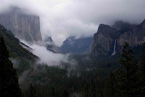
El Capitan and Bridal Falls from the Tunnel |
That road in is quite twisty turny and beautiful, deep in the
forest, with the occasional vista, as you would expect, but
eventually I got into the clouds and drizzle, over six thousand
feet, which was a bit dicey. I was glad it was not totally dark
then. Coming out of the tunnel you see the valley out in front of
you and the shots were very atmospheric, with haunting clouds. It
was dark by the time I tried to find the Yosemite Lodge, where I
stayed, in the valley. I was tired beyond belief, and there were
several false starts in finding a room. The first key didn’t
work, after having dragged my stuff quite some distance and over
mud, and back again, eventually I got great digs in a different
lodge near my car. They had wifi in the lobby, a rustic wonderful
place, and I had a lovely meal at one of the restaurants. I’d
eaten junk food all day in the car on the run. I thought that
going to sleep here I wouldn’t wake up with a migraine, as I had
most of the days so far, and I was right. |
This, only my second trip to Yosemite, was great.
I stayed two days this time, unlike the first time which was a train and
bus trip there and back in one day from San Francisco in ‘95. I’d
driven hard the day before so I could make the photography walk
conducted by the Ansel Adams gallery and photo shop at 9am. I learned
that the best photogs use a tripod for landscapes and of course, I’d
been seeing this over and over again, when I’d find a wonderful spot,
there would already be at least one photog there with his tripod. On
this trip, using the new heavier SLR, and encountering windy conditions
frequently, I saw the value of having a tripod. I’d tried to travel
light this time to spare my back, so left mine home. I hear they have
very small light ones now. The woman from the gallery took us to
Yosemite falls, which are one of the tallest in the world, beautiful
with a rainbow, blue sky above and a conical ice block at the bottom of
one (from the water freezing upon impact). We encountered groups of
deer and got nice shots of Half Dome. She even brought us to one of the
few sequoia trees in the valley. It was puny compared with the one I’d
had my picture taken with that afternoon just prior to the Fresno
concert two years back (where I lost the picture card later that
evening, searching through garbage in the back alley in great detail and
still not finding.) Once back in the gallery, I looked at some of the
books for digital nature photographers in the gallery and learned about
the utility of a warm filter (81A, B, and C). I’d been learning about
white balance recently, and decided to buy an 81B to try to enhance my
sunsets and reduce blueness of cloudy days. I bought another book which
has lots of nuts and bolts info. I was tempted by Ansel Adams reprints,
and the prices were reasonable, but didn’t buy any. I’m getting to be a
lot more selective of late since I don’t put up the stuff I do have,
hence buying more is not on.
| Later in the day I explored and got some more shots of Bridal
Falls and El Capitan and the whole valley near sunset, hoping for
that beautiful shaft of light to come in through the clouds that
had gathered and light up one of the sheer walls with brilliant
red-orange, but no. I arranged to have a massage the second
night, and this fellow drove all the way from the central valley
up to Yosemite Valley and back. Kirk was great (I needed it!) and
after I told him about the Moody Blues, touring and my photography
and playing guitar, he mentioned that he once worked on Rusty
Anderson, Paul McCartney’s lead guitarist, who asked for special
attention to his left shoulder (where the guitar strap sits).
That was kinda neat. I remember how Macca mentioned in his
concerts a couple of years back how he once had a “dodgy massage”
by a Japanese lady who sang Yesterday in a heavy accent and funny
voice as she worked on him. His recounting and imitation was
hilarious. |
 |
 |
|
The next morning I was up early again to drive up to Badger
ski area for the free snowshoeing hike. I was a little nervous
going up over 7,000 feet, but the roads were clear enough and I
had no problems getting up or down. This had been a slow snow
year thus far with only a few inches vs. the usual few feet on the
ground. Hertz had told me before that they wanted no chains on
their tires, that their tires were good enough. At Yosemite they
had said snow tires or chains were required for that road and I
didn’t learn until later that my all-weather tires were not snow
tires. Who knew? I figure, All Weather means All Weather,
right? But no. |
 |
At Badger, after getting these very complicated laces done,
the hike was neat and we were able to get away from the noise of
the ski center and into nature. The sides of the trees were
covered with lichen and/or moss, and we saw fresh bear scratches
on the sides of a couple of trees. These are black bears that
apparently don’t bother people much, though you have to sign a
form when you check into the hotel that you will remove everything
from your car that is edible. All the garbage cans there are
bear-proof and there’s a video going the whole time in the lobby
showing bears prying open cars and trunks and jumping into and
backing out of open car windows. In the afternoon, we were
treated to another hike, this one with the same fellow as the
morning, and featuring a talk about geology. I went to a spot
that’s supposed to have amazing hot color on a waterfall off El
Capitan only certain times in winter, and only with a clear sky.
But as sunset approached, the sky filled, and the dozen or so
photogs waiting there were disappointed. |
 |
My original plan for this afternoon and night had
been to head south to Kings Canyon / Sequoia National Parks and see some
big trees and possibly snowshoe out to Panoramic Point (I think that’s
what it’s called). But since it had snowed the night before, and they
required chains, I didn’t want to chance it. Plan B was aI was staying
at a colleague’s farmhouse out in the middle of nowhere. In the weeks
before heading out west, I’d been writing posts in a recycling online
forum, and Rose had written inviting me to present at the California
Resources Recovery assn conference in San Pedro this summer (hmmm.. can
we possibly link this up with a Moodies tour??). In addition to
agreeing to submit an abstract, I told her I was coming out the next
week. She invited me to stay. So, since I hadn’t had a chance to get
directions until this day, I didn’t know quite how far I was going this
night. I left Yosemite valley at sundown via the 140 route towards the
west. It was a long winding road at night. She called just after I’d
passed the appropriate exit in Merced, and directed me way out,
southwest, to her farm. We talked recycling and Moody Blues into the
night over a lovely California dinner. The next evening Pasadena!
|


